
Against the Brooklyn Bridge
New York City’s Great Bridge is Not a Very Good Bridge

If you grew up in Brooklyn, as I did, your feelings about the Brooklyn Bridge are not supposed to be very complicated. The bridge is all but sacrosanct to us, a universally beloved emblem of a borough whose residents disagree vocally about so much. Most regard it as unimpeachable, something fairly close to a local deity, and while nobody would bother commissioning an opinion poll to measure public sentiment about it, it’s pretty safe to assume that approval is nearly universal, comparable to attitudes about “parks” and “pizza.” Recently, however, I find myself asking whether the Brooklyn Bridge a good bridge, after all. I fear it might not be.
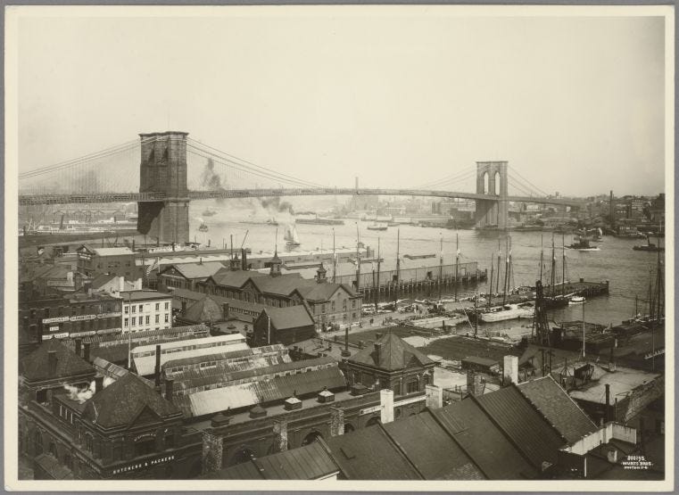
I’ll say as a disclaimer that I can’t honestly claim to dislike the Brooklyn Bridge. I spent my childhood in awe of the thing, staring up at it starry-eyed whenever it appeared framed between two rows of buildings. It was huge, and beautiful, and old, a relic from a city that existed before the big glass buildings (before the subway even), its handsome gothic towers straddling the gulf between Brooklyn and Manhattan. It was a triumph of the human spirit against the void, and against the general decline in the quality of everything that seemed to accelerate with the passage of time. The bridge stood out as grand and eternal, even against that world-famous skyline, and even to a teenager who believed everything around him was overrated, annoying. Who could resist that elegant granite? Not I, friends. It was a reminder, to me, that no matter how shiny, wealthy, or sophisticated the city became, we’d once been capable of better, more beautiful things.
The family saga of its construction, which somehow turned up twice in my middle school education, padded that larger-than-life aura. John Roebling, the eccentric engineer who designed it, died early in the construction process when a ferry crushed his leg (he might have survived, but he opted for something called “water treatment” instead of modern medicine). After his death, it fell to his son, Washington Roebling, to oversee the project, but Washington, too, sustained an injury, falling ill with the bends while inspecting a pressurized caisson below the foundation. Washington’s wife Emily Warren Roebling took her husband’s place, completing her father-in-law’s masterpiece as her ailing husband watched through a telescope from their Columbia Heights apartment, passing her notes by messenger. By the time the bridge opened in 1883, after 14 years of construction, dozens of builders had died working on it, with countless more injured. The structure was declared by many to be the 8th Wonder of the World, and indeed, to this day, it is breathtaking.
But the Brooklyn Bridge is not the pyramids, or the arc de triomphe. It isn’t a statue, or an artwork, or a monument (or at least, it’s not primarily things). It wasn’t built to be gazed at, or painted, and as much as I love to look at it, the Brooklyn Bridge is a piece of infrastructure, designed to improve how people move through and use the city, and it deserves to be assessed on that basis occasionally. As best I can tell, the words you are reading this very moment are the first in at least the last century to imply that it might leave something to be desired, but it does! As a piece of infrastructure, I believe that it fails.


To begin with, the bridge doesn’t fit cleanly into any of the New York City neighborhoods it connects. Examine the areas that surround its land-bound parts and you will notice coils of ramps and roadways that constitute its appendages and supportive infrastructure. These skirts of concrete create desolate, practically unusable zones on both sides of the East River. On the Brooklyn side, the slope that approaches the water from Camden Plaza could be one of New York City’s finest stretches of pedestrian space: an array of boulevards that fan out towards the water in several directions. Instead, this zone is split up by exit ramps and overpasses into islands that are unsuitable for any use. Several of the playgrounds in the area sit empty and dusty most of the time. Even Camden Plaza itself, bounded on all sides by roads that are always busy with bridge traffic, has a kind of insular quality, somehow less inviting than the grassless public spaces that flank Borough Hall to its east.
On the Manhattan side, the situation isn’t much better. The bridge spills pedestrian, cyclist, and driver alike into a chaotic bottleneck between City Hall and the Municipal Building, spreading nightmare traffic and chaos across the island on Chambers Street, and up the East River. The eastern edge of City Hall Park is, in no small part thanks to the bridge, one of my least favorite places to stand in New York City, constantly congested with cars and frustrated pedestrians alike. The area between the end of the bridge and the water is characterized, just as in the equivalent places across the river, by a desolate, unnavigable patchwork of underpasses and traffic islands, impeding the free movement of pedestrians in and around the shore. Those who want to cross the river by foot or bicycle are pushed significant distances inland from the water’s edge in order to access the bridge, especially on the Brooklyn side. Cars, meanwhile, are given multiple points of access on both sides in both directions, at the expense of the waterfront and everyone using it.
You can’t blame the Roebling family for all of this: the car was still a dream when they were working, and the bedrock and the elevation onto which the bridge has been transposed play some part in its shape. Still, both of the endpoints are significantly higher than the adjacent waterfronts, and the bridge eclipses those shores in its transit across the river, damaging the neighborhoods . On both sides, the waterfront is chopped up into oblivion, first by the span itself and then by the roads that feed it cars.
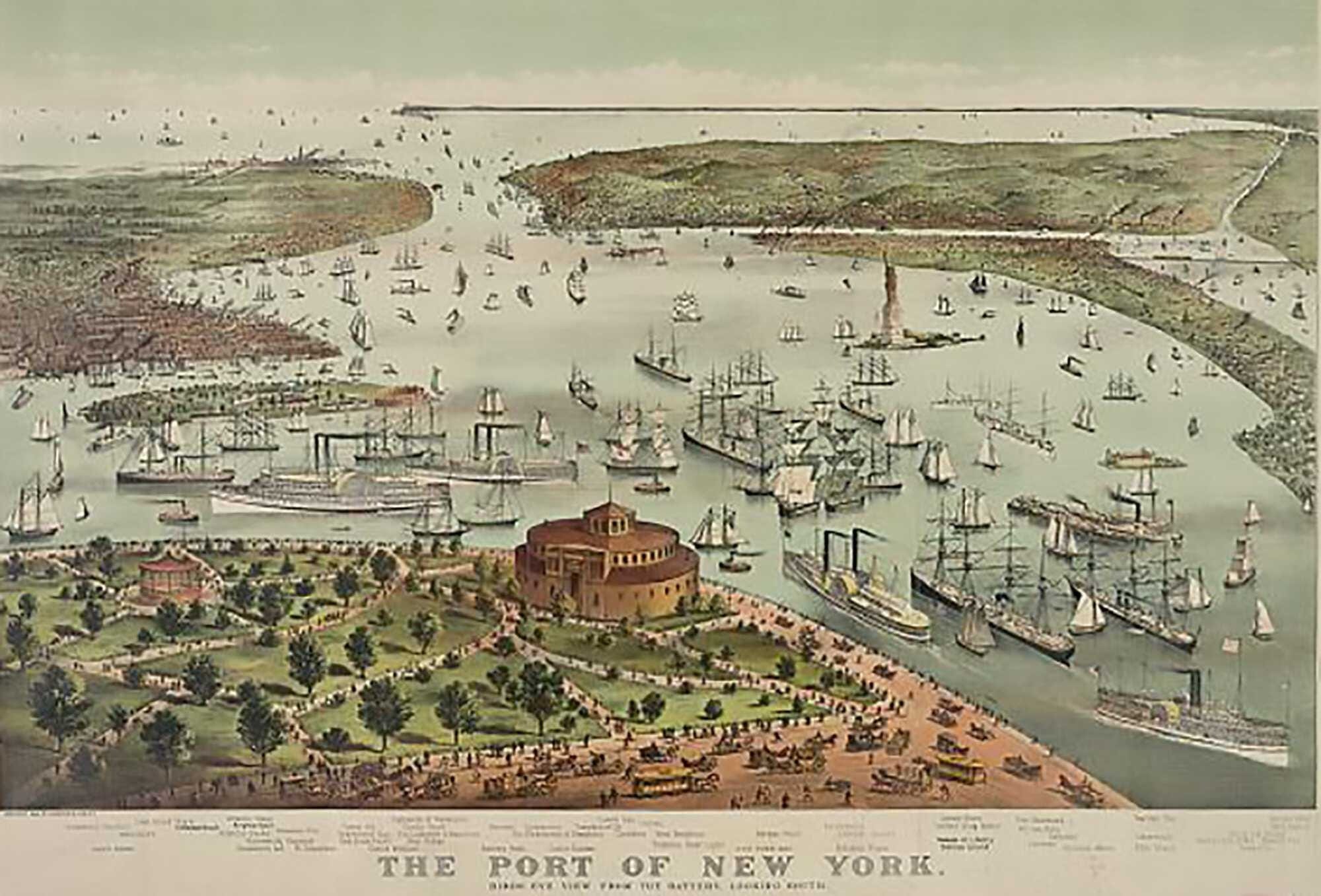
Before the Brooklyn Bridge was built (and here my central grievance becomes obvious to anyone who has been reading this newsletter for a while) New Yorkers got around on the water. The local bays and rivers were our subway and our highway: a network of waterways that, at all times of day, was full of vessels small and large. Bulky cargo ships sailed in and out of slips, carrying goods from ports the world-wide, while handsome pleasurecraft cruised up and down with the tides. Little workboats steered by enterprising sailors scouting for odd jobs wove between anchored cargo ships and steamers. All along the shoreline, dockworkers loaded and unloaded, while passengers spilled in and out of ferries with the ebb and flow of water and workday.
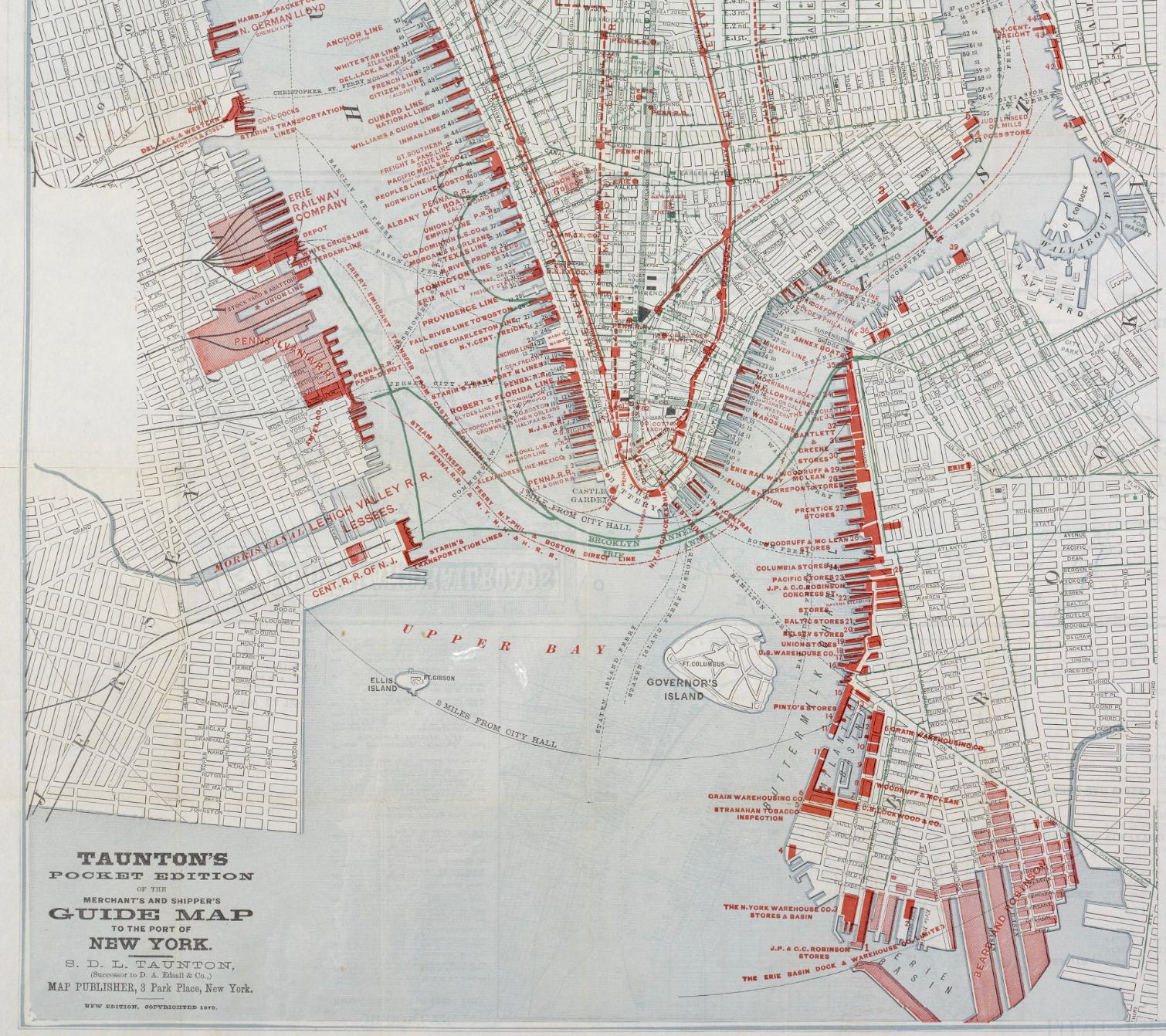
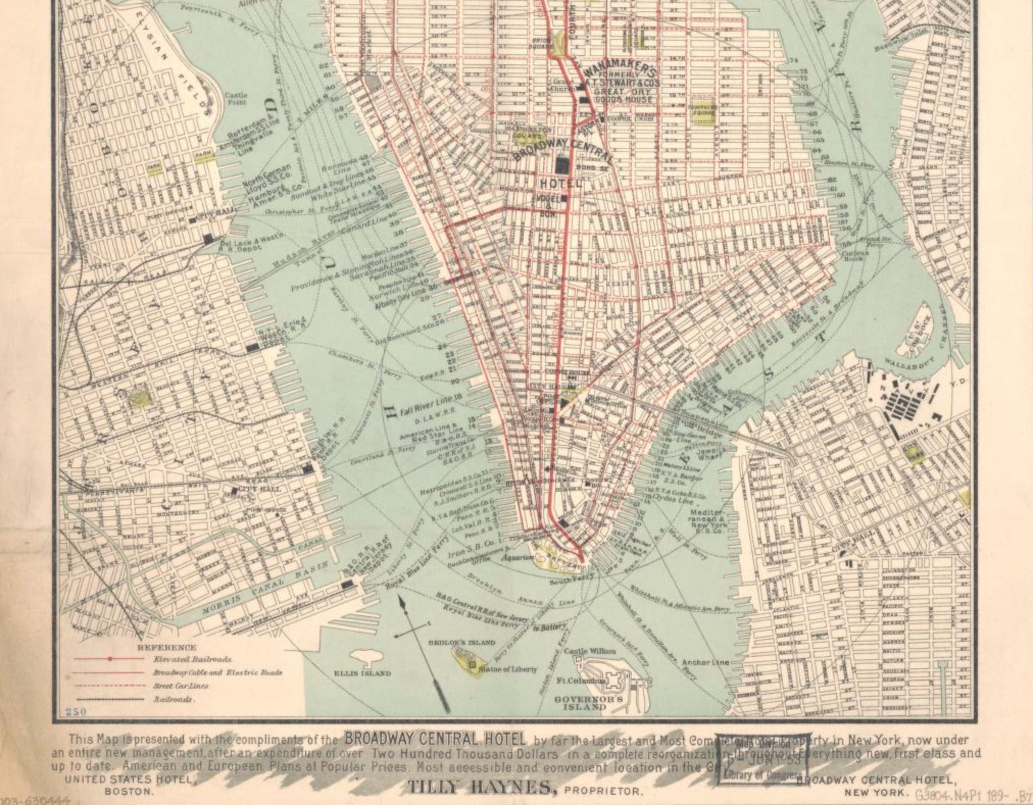
That activity bestowed upon the watery edges of New York City a special energy that virtually everyone writing from that time and place remarked upon. William Dean Howells described the views towards the water on Manhattan’s East-West streets as “lively, with their turmoil of trucks and cars and carts and hacks and foot passengers, ending in the chimneys and masts of shipping, and final gleams of dancing water.” The first chapter of Moby-Dick contains some of the best writing about the city’s shoreline and its effect on people, passages I’ve quoted here at Landlubber before, and can virtually guarantee I’ll quote again in the future:
Circumambulate the city of a dreamy Sabbath afternoon. Go from Corlears Hook to Coenties Slip, and from thence, by Whitehall, northward. What do you see?—Posted like silent sentinels all around the town, stand thousands upon thousands of mortal men fixed in ocean reveries. Some leaning against the spiles; some seated upon the pier-heads; some looking over the bulwarks of ships from China; some high aloft in the rigging, as if striving to get a still better seaward peep. But these are all landsmen; of week days pent up in lath and plaster—tied to counters, nailed to benches, clinched to desks. How then is this? Are the green fields gone? What do they here?
But look! here come more crowds, pacing straight for the water, and seemingly bound for a dive. Strange! Nothing will content them but the extremest limit of the land; loitering under the shady lee of yonder warehouses will not suffice. No. They must get just as nigh the water as they possibly can without falling in. And there they stand—miles of them—leagues. Inlanders all, they come from lanes and alleys, streets and avenues—north, east, south, and west. Yet here they all unite. Tell me, does the magnetic virtue of the needles of the compasses of all those ships attract them thither?
Part of the magic that these writers tried to bottle was, in my opinion, the sense of openness that the city’s shorelines communicated: the inter-connectedness of each of the city’s shorelines to one another, and to distant shorelines elsewhere, and the way that transiting the waters here connected people in different parts of the city, and different parts of the world, to one another. If I could, I would quote all of Walt Whitman’s poem ‘Crossing Brooklyn Ferry’ in this essay, but we’ll have to settle for a stanza or so (forgive the indulgence, I chose one on the longer side):
I too many and many a time cross’d the river of old,
Watched the Twelfth-month sea-gulls, saw them high in the air floating with motionless wings, oscillating their bodies,
Saw how the glistening yellow lit up parts of their bodies and left the rest in strong shadow,
Saw the slow-wheeling circles and the gradual edging toward the south,
Saw the reflection of the summer sky in the water,
Had my eyes dazzled by the shimmering track of beams,
Look’d at the fine centrifugal spokes of light round the shape of my head in the sunlit water,
Look’d on the haze on the hills southward and south-westward,
Look’d on the vapor as it flew in fleeces tinged with violet,
Look’d toward the lower bay to notice the vessels arriving,
Saw their approach, saw aboard those that were near me,
Saw the white sails of schooners and sloops, saw the ships at anchor,
The sailors at work in the rigging or out astride the spars,
The round masts, the swinging motion of the hulls, the slender serpentine pennants,
The large and small steamers in motion, the pilots in their pilot-houses,
The white wake left by the passage, the quick tremulous whirl of the wheels,
The flags of all nations, the falling of them at sunset,
The scallop-edged waves in the twilight, the ladled cups, the frolicsome crests and glistening,
The stretch afar growing dimmer and dimmer, the gray walls of the granite storehouses by the docks,
On the river the shadowy group, the big steam-tug closely flank’d on each side by the barges, the hay-boat, the belated lighter,
On the neighboring shore the fires from the foundry chimneys burning high and glaringly into the night,
Casting their flicker of black contrasted with wild red and yellow light over the tops of houses, and down into the clefts of streets.
These and all else were to me the same as they are to you,
I loved well those cities, loved well the stately and rapid river,
The men and women I saw were all near to me,
Others the same—others who look back on me because I look’d forward to them,
(The time will come, though I stop here to-day and to-night.)
I have tried and failed to count the ferry lines that served New York City in the 18th and 19th century, but there were many. Some connected with regional commuter rail lines in New Jersey, while others poured in from towns in Long Island and Connecticut, bridging gaps in the railroad networks in those places with a leg over water. Larger vessels trickled in on longer timetables from Boston, Newport, Asbury Park, and Bay Head. In addition to commuting by water, New Yorkers took boat trips to explore the areas surrounding the city, with so-called “excursion boats” making frequent runs out to the Rockaway Peninsula, the Long Island Sound, and up the Hudson River. Many of these ferries were spectacular, elegant, designed with care for heavy use.
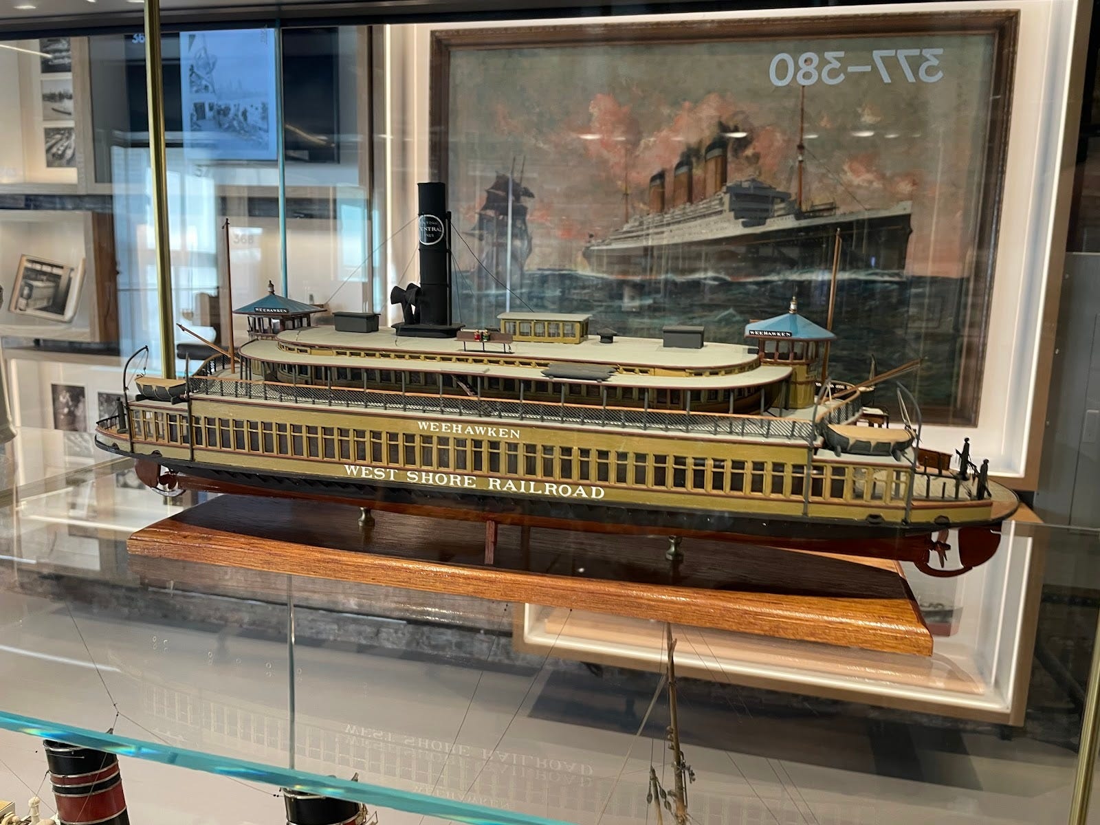
The Brooklyn Bridge killed that world, or played a large role in its demise. From 1883 on, local travel and shipping transitioned steadily towards carts, subways, automobiles, and trucks, removing New Yorkers from the waterfront at each step. A century later, the network of ferries here was a shadow of the old system, and virtually no freight entered the city by boat.
Not all of what transpired can be attributed to the Brooklyn Bridge alone—a network of tunnels and bridges followed, all of them designed to encourage the use of cars and trucks—but the bridge was the first domino in that chain reaction. In retrospect, the boat accident that fatally injured John Roebling could be thought of as a form of symbolic retribution in which the harbor itself lashed out at the architect of its demise, like a bee that in its final moments of life stings the arm of someone about to slap it.
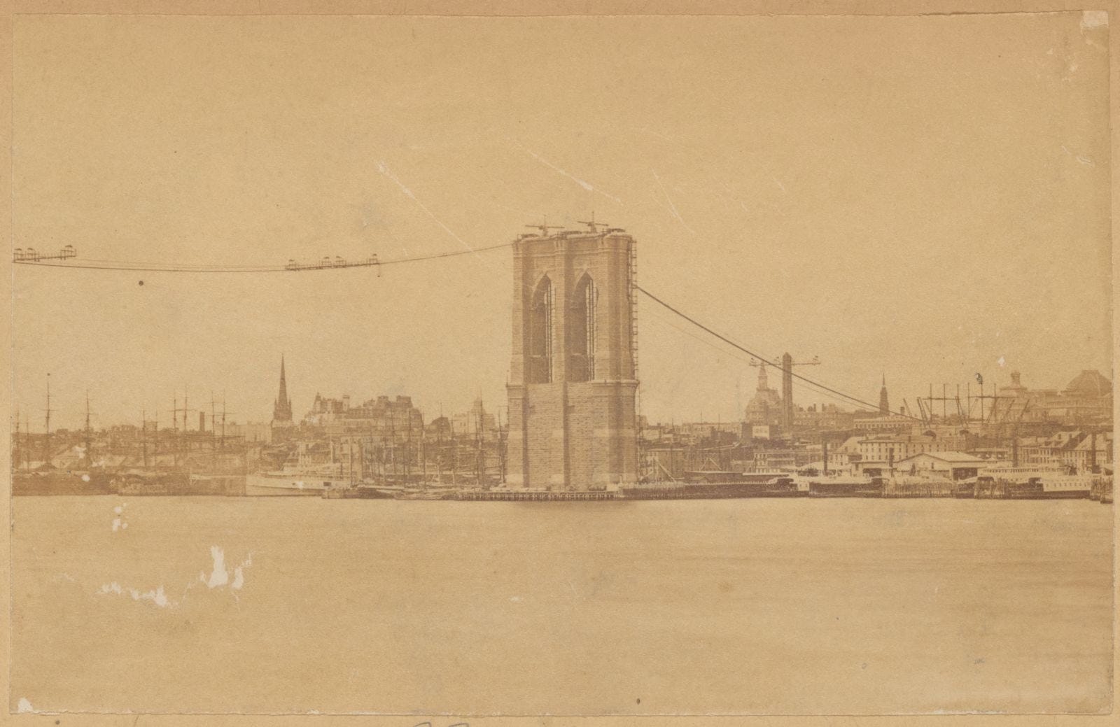
I am a believer that the waterways will once again become bustling here, though not without some thought and effort. A revitalization of wharves, docks, piers, and beaches for both recreation, transportation, and commerce will be necessary, and it will take a long time. Cities around the world that have poured work into rejuvenating their shorelines have seen incredible results, with public health improvements, economic benefits, and more. The water here is cleaner than it’s been in over a century, swimmable during dry weather, and we’ve only just begun remembering how to use it. Making big investments in the future of the shore is a no-brainer.
The Brooklyn Bridge, however, poses a problem that will eventually need to be addressed. The stretches of Manhattan and Brooklyn it eclipses should, by all rights, constitute the central hubs from which other points of access radiate out. If the harbor is going to be reborn in a way that’s useful to the entire city, we’re going to need to take that space back, reactivating it for heavy use. I would never suggest that the Brooklyn Bridge should be demolished, or removed, but it might need to be adjusted, with staircases and ramps added along its flanks to open it to the waterfront neighborhoods below, and some of the ramps that feed it cars removed. As it currently stands, it’s in the way.
PROGRAMMING REMINDERS:
CLASSIC HARBOR LINE TOURS:
These go down around the bottom of Manhattan, then up the East River to Hell Gate to visit the amazing wading bird colonies on some of the city’s abandoned islands over there. These tours include lots of history, amazing wildlife, and some of the most spectacular sunsets you can see in this wonderful city (as well as delicious food and a complimentary beer/wine).
Dates, with links, are:
NYC BIRD ALLIANCE TOURS:
The NYC Bird Alliance tours are along the Rockaway Beach Endangered Shorebird Nesting Area, and they’re FREE. We’ll observe nesting oystercatchers, piping plovers, terns and then, as summer continues, sandpipers and other long-distance migrants that stop over on city beaches to feast during their long journeys south from as far north as the arctic. Registration is encouraged but not required! Those meet at Beach 60th street and the Boardwalk in Rockaway and the dates and times are:
Thursday 7/23 5:30 PM - 7:00 PM (TOMORROW)
Saturday 8/15 10:00 AM - 11:30 AM
Saturday 8/22 10:00 AM - 11:30 AM
Saturday 9/12 10:00 AM - 11:30 AM (Link to follow soon!)
URBAN OMNIBUS TOURS:
A series of tours based on the essays about urban ecologies that I’ve been writing for Urban Omnibus this year. These are for people who become Urban Omnibus “builder members” of the Architectural League, a group that does lots of cool stuff throughout New York City during the year, or for anyone who donates $50 or more dollars to the organization. The league hosts lots of cool programs and events that touch on architecture and urbanism-type stuff around the city, and gives out awards and prizes to support people working on neat stuff, so there’s more to look forward to if you join. The tours are built to give people an up-close look at some of the stuff in this series here! The dates for the remaining ones are:
Waste-watering Holes - Saturday, August 16, 11:00 AM
A walk along the Newtown Creek Nature Trail and around the local wastewater treatment plant in search of wildlife that get by on the odd opportunities that the sewage treatment process presents.
Urban Shorelines - Saturday September 19, 4:00 PM
A look at the urban ecology of the city’s watery edges, this tour begins near the Pier 26 Tide Deck, which is a recent attempt to recreate a sliver of Manhattan’s bygone tidal shoreline habitat, and makes its way uptown towards the Hudson River Park Wet Lab, where participants will get to look at some of the wildlife that currently resides amid New York City’s current shoreline environment of piers and pilings.